
It is essential for Waikīkī and shoreline resort properties to prepare critical adaptation plans.
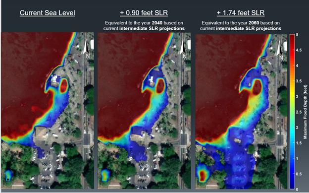
Numerous resort properties line the shores of the famous and iconic Waikīkī Beach, and has flourished for decades in harmony with the ebb and flow of the tides. However, rapid warming of the atmosphere and oceans, caused by unabated carbon emissions, is causing increasing rates of sea level rise (SLR) that threaten natural environments and developments along the coast. The projections of SLR over the next 20 years may have considerable effects to our shorelines, with estimates of an additional 1 ft rise in sea level by the year 2050 and 3 ft by 2080. The Honolulu Climate Change Commission is guiding long range planning for +5.7 ft SLR by 2100. Understanding how these hazards affect coastal properties is critical for long-term planning with respect to maintenance, renovations, improvements, and expansions.
G70 in coordination with Sea Engineering, Inc. (SEI) offer planning services to provide a comprehensive analysis of SLR that evaluates the impact of rising seas on resort properties and potential disruption to future operations. The SLR Assessment provides a path forward to plan for a safer, stronger, and sustainable resort for the foreseeable future.
It is essential for Waikīkī resort properties to prepare critical adaptation plans.
Sea Level Rise Challenges
Extensive modification of the original Waikīkī Beach shoreline has occurred to create the oceanfront features that exist today. As sea levels rise now and into the future, coastal natural hazard exposure, such as passive flooding, wave inundation, coastal erosion, and storm surge, is predicted to increase for properties close to the shoreline.
Passive Flooding
SLR results in upward pressure on the lens of freshwater beneath the land surface, which causes the groundwater table to rise. Passive flooding occurs when groundwater percolates out of the ground in low-lying areas or ocean water overflows through storm drains. Passive flooding is exacerbated by rainfall as it prevents drainage and as such, runoff and marine waters combine to produce larger impacts.
Property drainage, wastewater and utilities systems will be affected by rising groundwater.
Wave Inundation
SLR allows more wave energy to reach the shoreline resulting in higher wave runup and overtopping of the beach berm that can cause flooding. The wave climate in Hawai‘i is characterized by four general wave types: northeast tradewind waves, southern swell, North Pacific swell, and Kona wind waves. Tropical storms and hurricanes also generate waves that can approach the islands from virtually any direction. These wave conditions may occur at the same time. With rising sea level, wave energy will translate more directly to affected shoreline properties.
Coastal Erosion
Coastal erosion is the process by which local SLR, strong wave action, and coastal flooding wear down or carry away rocks, soils, and sands along the coast. Erosion threatens the integrity of structures and infrastructure located along the coast. Moreover, beach loss results in a variety of negative economic, social, cultural, and environmental impacts. Shoreline resort properties will witness an increased erosion trend with sea level rise.
Storm Surge
When severe storms such as hurricanes move toward land from the ocean, low pressure and strong winds and waves can push abnormally high water levels onto the coast. These storm surges can produce water levels much higher than normal high tide, resulting in extreme coastal and inland flooding. Storm surges will be larger and more frequent in the future.
Sea Level Rise Assessment & Analysis of Future Inundation
G70 in collaboration with Sea Engineering, Inc. (SEI), offer comprehensive SLR management planning services. This SLR Assessment defines future challenges faced by shoreline properties and offers recommendations and proactive planning design to ensure the continued success of commercial investments.
With high resolution planning and engineering techniques, future inundation of properties for selected SLR and wave scenarios are examined with possible mitigation options.
- Evaluation of design water levels, including elevated storm water levels and sea level rise (SLR).
- Assessment of wave conditions at the shoreline, including prevailing and storm conditions, and existing and potential future conditions incorporating SLR.
- Analysis of wave runup and coastal inundation for existing and potential future conditions incorporating SLR. Coastal inundation analysis would include expected frequency of occurrence.
- Assessment of coastal processes, including beaches and sand transport.
- Identification of required permitting and associated environmental and technical studies.
- Physical design and infrastructure adaption evaluation and strategies.
Together, G70 & SEI can help your organization to proactively assess current and future shoreline risk conditions, plan and design scaled response improvements, complete the complex environmental and permitting requirements, and execute your critical SLR adaptation plans.
For more information on SLR services, contact:
Tracy Camuso, Principal of G70 at [email protected]
Jeff Overton, Principal of G70 at [email protected]